Unleashing Nature's Fury: Exploring History's Most Devastating Volcanic Eruptions
By Sophia Maddox | April 11, 2024
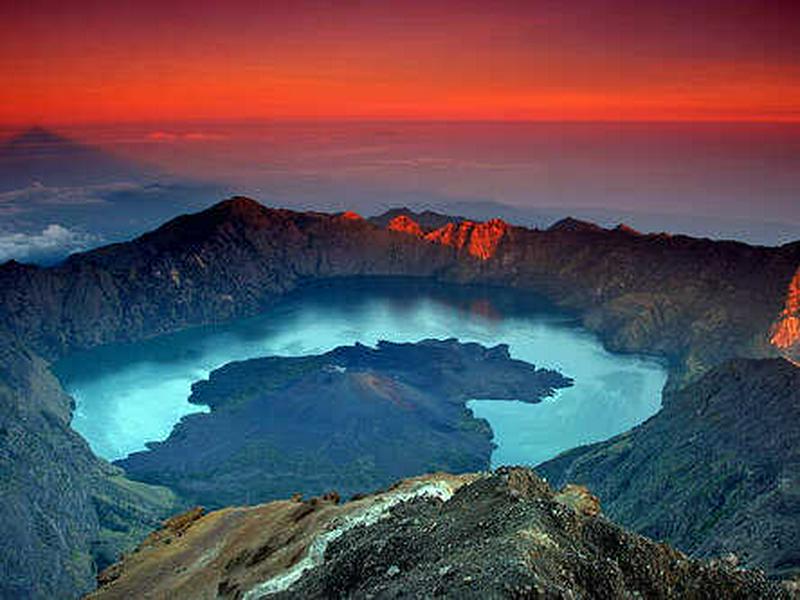
The Destruction of Pamatan City: Mount Samalas, 1257
Although volcanic eruptions can be awe-inspiring, they can also be incredibly devastating. Several volcanic explosions have stood out for their sheer magnitude and deadly consequences. From the ancient eruption of Mount Vesuvius in 79 AD, which buried the Roman cities of Pompeii and Herculaneum, to the cataclysmic event of Mount Tambora in 1815, which led to the "Year Without a Summer" and widespread famine, these eruptions have left scars on cities. More recent eruptions like Mount St. Helens in 1980 and Mount Pinatubo in 1991 have demonstrated the significant hazards posed by volcanic activity, causing loss of life, destruction of property, and environmental impacts felt around the world. Here are some of the deadliest volcanic eruptions of all time.
The Mount Samalas eruption in Lombok, Indonesia, stands out as one of the largest volcanic eruptions in recorded history. The explosion of Mount Samalas (pictured) expelled an immense volume of volcanic ash, gases, and rock fragments into the air. In addition, the eruption destroyed the city of Pamatan, the capital of the Lombok kingdom.
The eruption's magnitude and intensity likely contributed to global climate effects, including a temporary cooling of the Earth's surface due to the injection of sulfur dioxide into the stratosphere. Furthermore, the eruption created pyroclastic flows and lahars that destroyed surrounding areas, causing loss of life and destruction of the surrounding communities.
While historical records from the time are scarce, scientific studies, including ice core and tree ring analyses, have provided important information about how the eruption affected global climate patterns.
An Eruption and Then a Tsunami: Mount Unzen 1792
This still represents the Mount Unzen volcanic eruption in Nagasaki Prefecture, Japan, which is ranked as one of the deadliest volcanic disasters in the country's history. Before the eruption, experts recorded months of seismic activity and steam emissions, showing increased volcanic unrest. On May 21st, a massive collapse of the volcano's flank created a pyroclastic flow or a fast-moving mixture of hot gas, ash, and rock fragments. The mixture swept down the mountain's slopes.
The pyroclastic flow destroyed nearby towns and villages, including Shimabara and the former settlement of Hara. Roughly 15,000 people are said to have died. The eruption also created tsunami waves in nearby Ariake Bay, further adding to the destruction and loss of life.
A VEI-7 Eruption: The Mount Tambora Volcanic Eruption of 1815
This still depicts the eruption of Mount Tambora, located in Indonesia. Tambora's eruption was categorized as a VEI-7 event, the highest on the Volcanic Explosivity Index. The eruption spewed an immense volume of ash, gases, and rock fragments into the air, leading to widespread devastation.
Several factors contributed to the deadliness of this eruption. First, the expulsion of volcanic ash and gases caused many global climate issues, resulting in the "Year Without a Summer" in 1816. Crops failed, leading to food shortages and famine across the Northern Hemisphere. Secondly, the eruption created pyroclastic flows, which are fast-moving currents of hot gas and volcanic matter. The massive volume of ash ejected into the air led to long periods of darkness and reduced temperatures, worsening the eruption's global impact. The pyroclastic flows swept into nearby communities. The Tambora eruption claimed the most lives of any volcanic eruption - 92,000 - with people mostly dying from starvation.
Shockwaves That Shook the World: The Krakatoa Eruption of 1883
Located in the Sunda Strait, Indonesia, Krakatoa's eruption turned into a devastating event. The eruption started with months of increased volcanic activity and then ended with a series of powerful explosions on August 26-27, 1883. The eruption killed 36,417 people.
The eruption also resulted in the collapse of the volcano's summit, creating tsunamis that reached heights of up to 40 meters (130 feet) and destroyed coastal communities in the surrounding areas. The explosion itself was heard thousands of kilometers away, and the resulting shockwave circled the globe multiple times. As seen in this photo, the eruption ejected immense volumes of ash, gas, and rock fragments into the air, causing spectacular sunsets worldwide due to the scattering of light by volcanic aerosols.
The eruption of Krakatoa affected the global climate, leading to dramatic temperature drops and disrupted weather patterns in the years following the event. Despite the widespread devastation, the Krakatoa eruption also contributed to advancements in understanding how volcanic eruptions behave and their global effects.
The "Paris of the Caribbean" Loses 29,000 Within Minutes
This image shows the eruption of Mount Pelée in 1902, which is famous for its sudden and devastating impact on the Caribbean island of Martinique. Located in the Lesser Antilles, Mount Pelée's eruption took place due to a buildup of pressure within its volcanic system. On May 8th, a massive explosion completely erased the summit of the volcano, releasing a superheated cloud of gas and volcanic debris, or pyroclastic flow.
The pyroclastic flow ran down the mountain's slopes at speeds exceeding 400 kilometers per hour (250 miles per hour), destroying everything in its path. The city of Saint-Pierre, once known as the "Paris of the Caribbean," bore the brunt of the devastation, with nearly the entire population of around 30,000 inhabitants dying within minutes.
The Volcanic Eruption That Swallowed the Town of Armero
The Nevado del Ruiz volcanic eruption in Colombia is a tragic example of the devastating effects of volcanic eruptions. On November 13th of that year, after a period of intense seismic activity and volcanic unrest, Nevado del Ruiz (pictured) erupted. The eruption melted a glacier on top of the volcano, resulting in massive, fast-moving volcanic mudflows. The mudflows barreled down its slopes at speeds exceeding 60 kilometers per hour (37 miles per hour).
The mudflows swallowed entire towns and villages, including the town of Armero, where an estimated 23,000 people lost their lives. Despite early warnings from scientists, evacuation efforts were insufficient, worsening the tragedy. The Nevado del Ruiz eruption emphasized the importance of disaster preparedness, early warning systems, and community education in reducing the impacts of volcanic eruptions.
The Minoan Eruption and the Destruction of Santorini
The Santorini volcano eruption is also known as the Minoan eruption. Located in the Aegean Sea, Santorini's eruption was a huge event, estimated to have been four to six times more powerful than the eruption of Krakatoa in 1883. This is a realistic illustration of the event.
The eruption essentially destroyed the island of Santorini and led to the collapse of its central caldera, forming the distinctive crescent-shaped archipelago seen today. The explosion created massive tsunamis, which spread across the Mediterranean, causing widespread destruction to coastal settlements and maritime trade routes.
The eruption's climatic effects likely contributed to the decline of the Minoan civilization on Crete Island and other nearby cultures. The volcanic ash and aerosols released during the eruption may have led to short-term global climate cooling, affecting agricultural productivity and disrupting life in the surrounding areas.
The Destruction of Pompeii: Mount Vesuvius 79 AD
The eruption of Mount Vesuvius in 79 AD is one of the most infamous volcanic events in history, largely due to its horrific impact on the Roman cities of Pompeii, Herculaneum, and the surrounding areas. Located near Naples, Italy, Vesuvius erupted explosively, ejecting tons of ash, rock fragments, and volcanic gases into the atmosphere. This eruption also included fast-moving avalanches of hot gas and volcanic debris, as shown in this illustration. The debris swallowed up the cities of Pompeii and Herculaneum, preserving them in ash and pumice.
The eruption took thousands of lives and buried the cities under several meters of volcanic material. The rediscovery of Pompeii in the 18th century provided invaluable insights into Roman life and culture. Vesuvius remains an active volcano today, with eruptions threatening the millions of people living nearby.
Laki and Grímsvötn and the Loss of a Large Portion of Iceland's Population
Depicted here, the Laki and Grímsvötn volcanic eruptions in Iceland were a series of fissure eruptions along the Laki volcanic fissure and an eruption at the Grímsvötn volcano. Over an eight-month period, these eruptions released large amounts of lava, sulfur dioxide, and ash into the atmosphere. Haze from the ash and lava was seen and felt from Iceland all the way to Syria.
The volcanic gases, particularly sulfur dioxide, led to the formation of sulfuric acid aerosols in the atmosphere, which led to a cooling effect globally. This resulted in widespread crop failures, livestock losses, and famine in Europe. Nearly one-quarter of Iceland's population died, largely due to famine. In addition, the release of volcanic ash and gas had negative effects on air quality, causing respiratory issues and higher death rates in humans and animals.
Mount Kelud Erupts a Second Time in 1586
The Kelud volcanic eruption in East Java, Indonesia, was a shocking volcanic event in the region's history. Although Kelud (pictured) is known for its explosive eruptions, the 1586 event was particularly catastrophic. The eruption produced pyroclastic flows or fast-moving avalanches of hot gas, ash, and rock fragments. The pyroclastic flows ran down the volcano's slopes, destroying everything in their path.
The eruption ejected a massive column of volcanic ash and gases into the air, which led to widespread ashfall, covering surrounding areas and affecting communities far beyond the immediate areas of the volcano. The eruption also created lahars (volcanic mudflows). These mudflows flowed into nearby valleys, causing additional destruction and loss of life. The death toll is estimated to be about 10,000.
The Volcanic Eruption That Formed the Massive Crater "Santiaguito"
The Santa María volcanic eruption in Guatemala is one of the most powerful volcanic events of the 20th century. Located in the Western Highlands, the eruption was preceded by several months of seismic activity and volcanic unrest. On October 24, 1902, the volcano in this photo violently exploded, sending massive amounts of ash and volcanic gases into the air.
The eruption resulted in swift-moving currents of hot gas, ash, and rock that essentially destroyed the surrounding countryside. Entire villages were destroyed, and about 5,000 people died. The eruption's intensity was made worse by the collapse of the volcano's summit, forming a massive crater known as the "Santiaguito." The volcano remains active today and must be monitored continuously to protect the local populations.
Mount Kelud Erupts a Third Time in 1919
Because Indonesia lies along the Pacific Ring of Fire, it is especially vulnerable to volcanic eruptions. Mount Kelud has erupted in 1901, 1910, 1919, 1951, and 1990. However, the 1919 eruption shown here was the biggest one. The Kelud volcanic eruption took place on May 19th, following seismic activity and volcanic unrest in the previous days.
The eruption produced powerful pyroclastic flows, which traveled down the volcano's slopes at high speeds, devastating everything in their path. Moreover, the eruption ejected a ton of volcanic ash and gas into the air, resulting in widespread ashfall across the region.
Significant damage was done to buildings, agriculture, and local communities. The ashfall affected transportation and caused respiratory issues for nearby populations, and the mudflows killed about 5,000 people.
A Short Eruption With Deadly Consequences: Mount Galunggung in 1822
On October 8th, after months of seismic activity, the Mount Galunggung volcano erupted, sending volcanic ash, gases, and rock fragments high into the atmosphere. This image shows this devastating event.
The eruption caused pyroclastic flows that traveled down the volcano's slopes, causing widespread devastation to surrounding areas in West Java, Indonesia. The eruption also spewed large amounts of ash and gases, which led to ashfall affecting communities tens of kilometers away. Although the eruption was relatively short, it was categorized as a VEI-5, and it killed 4,011 people. The volcano is still active.
Mount Vesuvius Summit Shortens After the 1631 Volcanic Eruption
While many are familiar with Mount Vesuvius and the destruction of Pompeii, fewer know about its equally devastating eruption in 1631, which claimed a large number of lives.
On December 16th, 1631, Mount Vesuvius began to erupt and finished the day after. It was categorized as a VEI-5 and produced moving avalanches of hot gas, ash, and rock fragments that swept down its slopes, swallowing nearby towns and villages, as depicted in this illustration.
The lava flows killed an estimated 6,000 people and damaged infrastructure and agriculture. After the eruption, the summit of Mount Vesuvius was reduced by 450 meters. Entire villages were wiped out, including Bosco, Torre dell’ Annunziata, Torre del Greco, and Granatello. In addition, Ercolano, the ancient Herculaneum, suffered a second time. The casualties could have been even greater if not for a brave rescue mission carried out three days later to save stranded villagers.
The Eruption of a Submarine Volcano: Ritter Island, 1888
On the morning of March 13th,1888, a massive chunk of the Ritter Island volcano crumbled into the Bismarck Sea northeast of New Guinea. This landslide was about twice the size of the Mount St. Helens landslide in 1980, making it the largest volcanic sector collapse ever recorded in history. The collapse shown here caused a tsunami that surged to heights of tens of meters. Even when the waves reached parts of the island of New Guinea, hundreds of kilometers away, they were still as high as eight meters, as reported by witnesses of the event.
Ritter Island is a submarine volcano, and the eruption in 1888 caused what is known as a "flank collapse." Flank collapses take place near sea level. When a hillside near the ocean suddenly collapses, it causes a chunk of land to slide downhill. The tsunami swept across the surrounding seas, causing widespread destruction to nearby coastal communities.
The Beauty and the Beast of the Mount Papandayan 1772 Eruption
Mount Papandayan (pictured) is a stratovolcano. A stratovolcano is a tall, cone-shaped volcano formed by layers of lava, ash, and other volcanic materials that build up over time. These volcanoes are known for their explosive eruptions. They're also called composite volcanoes because they're made up of different materials from various eruptions. On August 11th, Mount Papandayan erupted, sending ashfall and lava flows into the villages below. Almost 3,000 people were killed, and 40 villages were destroyed due to the ashfall.
Today, Mount Papandayan attracts many tourists. Visitors can explore the crater, witnessing natural phenomena like bubbling mud pools, steam vents, and sulfur deposits. One of the highlights is Papandayan Crater, a striking yellow crater.
The Surprise Eruption of Mount Lamington in 1951
In January of 1951, small explosions and earthquakes occurred at Mount Lamington, a volcano in Oro Province, Papua and New Guinea. The volcano in this photograph had been dormant for centuries. Furthermore, it was covered in thick plants. Still, several days before, people in the area noticed the summit of the mountain changing.
On January 15, the volcano became more active, and big clouds of ash erupted. The biggest explosion happened on January 21, sending a huge column of ash 15,000 meters (50,000 feet) high. It caused part of the volcano to collapse and created a fast, hot flow of gas and rocks. Almost 3,000 people died as a result. This was the deadliest natural disaster recorded in Australian history, as Papua and New Guinea were under Australian rule at that time.
An Active Volcano That Keeps Erupting: Mount Awu, 1856
Mount Awu, the largest volcano in the Sangihe chain, sits on Sangir Island in North Sulawesi, Indonesia. It unleashed powerful eruptions in 1711, 1812, 1822, 1856, 1892, and 1966, causing devastating pyroclastic flows and lahars.
On March 2nd, 1856, the Awu volcano erupted, as shown in this image. Between 7 a.m. and 8 a.m., people reported hearing a big boom, and lava started flowing down to the sea. The eruption killed 2,806 people.
The volcano remains dangerous and active due to its ongoing lava formation. Adding to the danger, rain fills a lake within its crater, creating a risky mix of water and lava that could trigger large explosions. At the peak, there's a crater spanning 4.5 kilometers in width.
The Eight-Month-Long Eruption of Oshima Oshima
The Oshima Oshima eruption (pictured) began on August 18, and it could be seen from Hokkaido by August 23. Two days later, on August 25, so much ash had been spewed out that it blocked the sunlight in the immediate area. In some places, ash fell more than 20 centimeters thick. Then, on August 29, a bigger, more violent eruption took place. This was followed by a huge tsunami, reaching up to 90 meters (300 feet) high. The tsunami swept away many coastal villages and towns along the Sea of Japan.
In Kaminokuni, 50 homes were wiped out by the waves. Around the Matsumae Peninsula, thick ash from the eruption made the villages dark. Then, the tsunami hit the shores sometime between 8 p.m. and 10 p.m. The waves were reported to be more than 9 meters (30 feet) high. About 120 kilometers (75 miles) of land was flooded, and at least 1,467 people lost their lives. Also, the waves destroyed 1,521 fishing boats and ships near the erupting volcano.
Canada's Worst Natural Disaster: The Tseax River Cone Eruption
The Tseax Cone volcanic eruption, also known as the Tseax River Cone eruption, is considered to be Canada's worst natural disaster, with about 2,000 people losing their lives. The volcanic site (shown here) consists of two cinder cones, a wide area covered by volcanic debris, and a 32-kilometer-long river of lava. Recent studies using different types of data suggest that all the volcanic material at Tseax was created during one period of volcanic activity.
The eruption began with gentle bursts of fire, forming a small cinder cone about 60 meters wide and a larger spatter cone measuring 460 meters wide. Then, more intense bursts created a tall column of ash over five kilometers high, lasting for about a day. This phase made a bigger cinder cone and spread ash mostly towards the northeast. The last part of the eruption was the lava flows. The lava flows from the eruption created the Tseax River lava beds, which covered an area of approximately 32 square kilometers (12 square miles).